Maximize
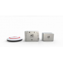
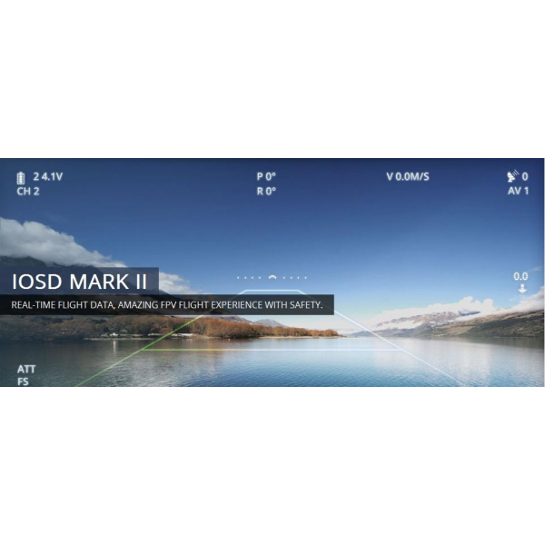
WKM + 50 WP + Data link 2.4G BT + IOSD MarkII
- Remove this product from my favorite's list.
- Add this product to my list of favorites.
 Maximize
The earth station Wongkong -M Waypoint is the improved version of the earth station Wongkong -M single waypoint version . Improve it waypoints editing function of ground control software product line .. DJI waypoint Waypoints Provides the control mode by F the channel general purpose servo action , and 6 Templates of route. The maximum waypoints That could be added are 50.También supports change and edit the flight path before During the flight.
Specialized Station Of multirotor autopilot system
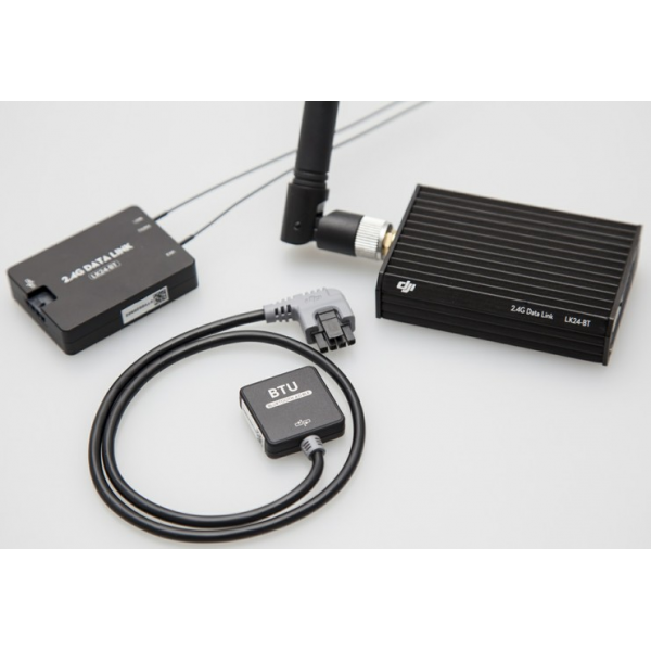
secure datalink
DJI provides data link and 900MHz to 2.4GHz Achieve wide range bidirectional communication . The maximum data link distance is up to 15 km. Extreme earth also binds with the USB power source that is convenient to use the outdoors. The module uses TO FHSS wireless technology checks That FCC and CE certification for it , the DJI Datalink has many advantages such as high data rate, stable performance , anti - interference fuertecapacidad , and wide alcane distance communication . The power consumption of 550mW datalink ince 2.4GHz and 900MHz 1.5W consime datalink , que is great advantage to large distance flight missions .
Reliable Datalink
Control algorithms of Professional Flight
The complete system ground control system , GPS, 6DOF IMU , magnetometer and barometric sensor combine to optimize robustness of These algorithms it logical and robotic control. Control of the land use system GPS / INSavanzadas patented technologies throughout the design algorithm . Included in adverse conditions , high vibration and high -demand environments , the flight if multicoptero maintains the accuracy rate stability to ensure the mission success .
Industrial Flight Control Algorithm
Quick capture GPS satellites / easy calibration of the compass
The design and components of the system using one high quality Quickly Allows Acquisition of GPS satellites . Calibrating the compass with the tolerance 45 ° is more easy and more faster than previous models them
Google 3D Maps
DJI Station designed on the ground around them 3D Google Maps, GIS also provides data. The operating plan can pilot and flight routes at any place, the PC mouse for use zoom in / out 3D maps , maps can download them to your pc if you can and use one in place, offline.
Google 3D Map
Monitoring flight data in real time
Besides the location aircraft heading and altitude, our land station also other devuelo Provides data as it attitude, airspeed, vertical speed , throttle and the pitch servo voltage Fraction and all times .
Real -time Monitoring flight
Failsafe auto return / A return of the house key
The ground station system Equipped with intelligent adaptation. During her abnormal signal loss , the average system to activate apropiadamenteel ajustarácon fail safe . The Avion take Cable route and had completed mission by defectoautomáticamente , if included when it loses signal data link .
When in the User ' s Manual mode, it is kept in Expects aircraft when RC signal lost . But after 10S, if the signal returns the addresses in tickets to the point of takeoff and returns precisely the route and the height segura.Entonces The Avion is hanging over the Automatically after takeoff point That point of activation. This feature provides security protection for smart air of User expensive equipment. In addition, the User can click Pin always change the current system it immediately interrupted mission of the order of the returning aircraft to support the point of takeoff .
Keyboard / Joystick mode
Can the operator using the keyboard joystick with the ground station system to check them multicoptero movements pose the slant and the DJI Datalink . The manual mode can apply when the radio ( Transmitter) signal reach it using the keyboard command control . This provision / feature lets you control when the radio ( Transmitter) That leaves working after it has begun mission
easy interface
DJI facility emphasizes the principle used in all designs, land station offers a 3D graphics interface , great go from the traditional system of UAV system with the ease of use and ease less complexity compared to others on the market . DJI ground control station can save time , improve efficiency of operation , ease of planning of Missions Support Flexible and intelligent monitoring for any mission.
User -friendly interface
Click & Go
Click on a 3D map any point in the plane can reach the point coordinate Automatically , Particularly useful when some of the routes can not be anticipated by Establishing . Altitude of vueloy devuelo speed can also adjust Quickly and accurately according to the change of data and points of interest when you change the User That flight mission and goal
Click & Go
Automatic flight BVR
Beyond visual range ( BVR ) System of the stations of the land designed to upscale commercial and Industrial automatic flight That requires a reliable device wide range wireless communication ( data transmission ) and the control system ground station (GCS ) . The flight path of Predetermined Action photographs , ylanzamiento from the air if you can plan in advance to control ground station software.
Auto takeoff / landing
The development of advanced driver offers automatic takeoff and landing can aplicarusando feature either keyboard transmitter radio station earth. Takeoff and landing speed ( ascent and descent ) is 0.2 to 0.5 meters per second
50 waypoints
Waypoints may Establishing if the number of up to 50 destinations . They are the basic unit composiciónencargados routes to Complying with the requirement of complex flights in operation. Users may make them ajustesespeciales for each landmark, such as her tall , latitude and longitude , speed of flight , Nose and turning towards lospatrones residence time, etc. . User can batch them all destinations through the establishment at once if necessary.
50 defined waypoints
3 ways of turning on waypoints.
There are 3 different planning modes : Mode Spinning the landmark , so the coordinated turning and turning coordinated mode of adaptation.
Mode of Punto Fijo : plane flies in the first landmark accurately , and then stay in the landmark and then fly to fixed anotherPoint . The fixed points and also can stay duration each set of advance.
So turning coordinated : The path of the aircraft is Estimated with speed and turning angle of rotation . The helicopter volabade one point to another without stop .
Adaptable coordinated way of turning : It's almost the same performance with coordinated Power mode . However, rutin flight with greater precision will detailed routine flight planned This Way .
3 turning waypoint mode options
2 Waypoint Altitude Display Mode
Data of flight altitude in real time, of vital ideas importance is the harvesting of flight data in real time. Determines correct Altitude Adjustment Waypoint Mission Success flight . There are of screens for her height , average height and her elevated mode . In the normal height , the system records the helicopter the value 0 reference point on top of it by height ( + ) means for on top of the soil and ( - ) value means underground. In so high , the same height as it helicópteroes elevation as Google Map. Owed it to altitude, the sensor may be Affected by climate conditions and a shift in altitude may be necesssary . Please refer the detailed configuration manual.
2 Waypoint Altitude Display Mode
Custom servo control channel
DJI autopilot system outputs Provides the servants to support custom servo function. These can be used is dossalidas Between the controller and additional devices. These outputs by example , if the operation can utilizarpara firing chamber , it parachute or other activation of commutation devices
Servo Control Custom Channel
Adjust the Route Waypoint
During the flight mission of the task start, the delay and the repetition time is can adjust . When Establishing time period , repetition time , and repeat them start retardation parameters of time, the operator can customize These functions for specific application.
Batch task route setting
Editing flight path in real time
During flight the La Mision operator can return to edit it as it mission modification of Flight routes , owaypoints to Achieve in a real setting goals to complete them long . The operator also can click on the "Pause " to suspend La Mision , if multicoptero button will keep the new awaiting allocation . And when signal if it is lost, the intelligent system for choosing the optimal route back the house automatically.
Editing Real -time flight route momentarily
Control channel F
User can also customize them channel outputs F1 and F2, to Achieve the extra device functioning as Servant , gimbaly control of the camera . ( Note : only WooKong supportF1 -M , F2 )
F channel controller
Using Relative Coordinates Editor
Regarding exact coordinates editor is a tool regularly drawing geometric figures on a 3D map . The operator puedeconfigurar one initial reference point , then the next waypoint distances with angles and details. The control system will calculate the ground next to the waypoint coordinates accurately.
Using Relative Coordinates Editor
Simulate
The control system of land can simulate actual environment on the flight, the operator does not have to perform to complete it Real misiónen flight simulation mode . The simulation mode is good for training and testing mission
Simulation
Loading / unloading data from the mission
All routes can be saved and exported to PC